Search This Blog

Tuesday, August 24, 2010

HIMACHAL DRIVING HOLIDAY - 2010 By Roopa Sreedhar (9886162404)

© TAG INDIA www.tagindia.net

HIMACHAL DRIVING HOLIDAY - 2010 By Roopa Sreedhar (9886162404)


Participant Interest Form @ http://spreadsheets.google.com/viewform?hl=en&formkey=dEVXQjRFZ1ZRV3lwLU9SYVVMajkwb2c6MA#gid=0


28 August 2010: 5:30 pm @ 36, Chandralok, Janpath, Delhi. The night journey to Manali in a semi sleeper. Simple Dinner awaits at Karnal. We hope to reach Manali by 10 am the next day. Here begins one of the most exotic journeys of India.


29-August-2010: We arrive at Manali by 10 am if there are no delays. After a sumptuous breakfast, we check in into the hotel booked for the day. A day tour of Manali takes us to the famous HADIMBA temple; allow us to stroll in the local markets and lose ourselves in the magic of this small hill town. We can capture in our memory the experience of eating local dish Shidu.


30-August-2010: We leave Manali to move southward. Indulge in a short trek up to Banjar fort on the way, visit Sojha & cross Jalori Pass to reach picturesque Gushaini by dawn.


31-August-2010: Relax at Gushaini.


1-Sep-2010: After a much needed break at Gushaini, we leave very early in the morning towards Manali for a very quick lunch. We move ahead to Keylong for night halt. We cross the Rohtang Pass, visit Beas Kund, the origin of mighty river Beas. Driving on the edge of the cliffs that overlook the fierce Bagha & meandering Chandra rivers, we reach Keylong.


State:
Himachal Pradesh
Distt: Lahaul & Spiti
Destination: Kaza
Climate: Extremely cold during winter and difficult to approach, temperature drops well below even -20 degrees, cold during summer. Rainfall is almost zero and Heavy Woolens both in Summer Winter.
Altitude: Kaza is situated at an altitude of about 4,270 meters.
Best time to visit: Mid-June to Late October.


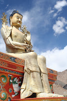
2-Sep-2010: We leave from Keylong & explore Kardang, Tayar & Guru Ghantal Monasteries. Rangrik, with the view of Key Monastery perched on high cliffs, is our destination. Barren mountains & desert like ambiance yet cold and comfortable, not to be found in any other part of the world.

3-Sep-2010: Time to explore the Spiti Valley, Key Monastery, Kibber Village, highest village in the world which is connected by motor-able road, Dhankar with an ancient fort and an 800-year-old Dhankar Monastery.


4-Sep-2010: Pin Valley

5-Sep-2010: Tabo Kaza Nako :At nearly 10,000 feet, Nako is like a green oasis in Spiti's high altitude desert. Kungri: Spiti's second oldest monastery is located in the Pin valley 45 kms from Tabo. The Kungri gompa was built around 1330 AD. Dhankar

6-Sep-2010: Chandratal: Chandertaal is situated at an altitude of about 4,270 meters. Camping next to this lake is one of the most beautiful experiences of the holiday. The sky is so clear that we can see the Milky way galaxy and zillions of stars shining down upon us.

7-Sep-2010: Back to Manali by Lunch gives us the whole evening to rest and get ready for the long journey ahead the next day.

8-Sep-2010: On the way to Dharamashala.


9-Sep-2010: Spend first half of the day soaking in the sights of Dharamshala, we pay homage to Dalai Lama. Post lunch we leave for Jammu. Arrive at Jammu by dinner time. The next day, we are to leave the embrace of Himalayas. Time to reflect upon the nature and our connection to our surroundings.

10-Sep-2010: Adios to all amigos! A sigh of contentment of having been in paradise once. When Buddha beckons & Himalayas call, how can one resist? Am sure we will come back again & again & again.........


If you are interested in joining us do fill up the Participant Interest Form @ http://spreadsheets.google.com/viewform?hl=en&formkey=dEVXQjRFZ1ZRV3lwLU9SYVVMajkwb2c6MA#gid=0


Best Regards,
Roopa Sreedhar
roopa.sreedhar@tagindia.net

9886162404


© TAG INDIA www.tagindia.net

Friday, August 6, 2010

Flash flood in Leh! Are you kidding me??? by GIRIDHAR B G

Just saw the news that Leh had flash flood due to cloud bursts yesterday. Around 60 people have been killed and more missing! My first thought was.. "you must be kidding me" and I will explain why I thought so in detail below.

Read news details on the flood at:
Flash floods kill 59 in Leh, more missing

Leh (Ladakh region) has a cold desert climate with 90mm rainfall/per year only. How is a desert area getting flooded out of the blue (quite literally speaking)? You may want to attribute this to global warming, but the theory of global warming itself is a big fallacy as I had documented in one of my
previous blogs.

I have personally traveled to Leh couple of times (read my blog with photos on Leh trip), and this is a mountain desert! The sources of water are glaciers melting and becoming rivulets. The mighty rivers include Indus and Zanskar that are completely fed by the glaciers and they melt due to the warmer conditions in Leh.

Curiously though, our neighbor China, who shares a border with Ladakh region, has been using cloud seeding techniques to create artificial rainfall to ease drought conditions in their southern region. Watch a Chinese news broadcast on the same topic.


The science of making artificial rain is now a reality. China used this technology quite heavily in Beijing during Olympics & to reduce pollution as well. Technology can easily become another commercially viable operation or even a military one used to spread havoc on a country's economy. Send fighter planes to drop these heavy particles into regions and trigger flash floods. If you still think I am talking science fiction watch this video on how this technology is being harnessed on regular basis: Humans make Rain


Could this technology be the cause of flooding at Leh? Is some one using this latest invention as another form of attack on the J&K state, which is already struggling in Kashmir on terrorism & civil unrest? Ladakh is the most stable region in J&K with strong military presence to guard our borders. It is also one of the main conduits for food and other supplies to the entire region and a major tourist destination. Most of the people are peace loving and all regions get along fine here. Many Tibetan migrants have found peace and solace establishing their homes here. It is not easy to instigate the people here unlike in the Kashmir valley. Leh is an integral part of India and the only way to destabilize this region is by using natural calamities. I am praying this is not the case and that this is once in a blue moon freak accident.


With the modern discoveries, intelligence communities of nations have to also upgrade their knowledge on how these could be used as potential weapons of mass destruction. Our ancient stories talked about man messing with the weather causing wide scale floods and destroying much of humanity. Vishnu's first avatar as a fish documents this in detail and resembles Noah's ark story quite closely. This is also documented by the Sumerian scriptures which predate the Bible by at least 4000 years and are probably one of the oldest surviving written scripts of mankind. Mankind with its selfish interest can bring upon itself a self destructive force which may not be controllable in the long run.

Don't mess with mother nature, her slight shrug can send continents crashing. You have been warned again.


Giridhar B G

Wednesday, August 4, 2010

Dream Route: Mangalore to Bangalore - Train Journey by JAGANNATH DAS C R

Mangalooru Bengalooru Train Journey By JAGANNATH DAS

Participants: Jagan, Vijay, Phani, Gopi, Vaishu


It was 8.40 AM. Train started for Bengalooru from the Mangalore junction, situated barely 36 feet above the sea level. It was dream route to travel & the dream came true on 22 September for us. As usual, we cousins, Jagan, Vijay, Phani, Gopi, Vaishu, booked seats well in advance. The journey started through the plains. The train started ascending slowly in the hilly region and we crossed low lying hills, few curves, areca nut and coconut plantations and small rivers. Some of the stations that we passed on the way were Buntwal, Kabaka & Puttur. Near Panemangalur, the train crossed the Nethravathi River via a high placed, long bridge. The train reached Subramanya road at 10.40 AM, a mid-sized station surrounded by lofty hills. Here, the train was at 380 feet above sea level. Two more Diesel WDC Locomotives were added to back end. This was to help push the train in ascending Ghat section; the switch took well over 20 minutes. The 3 stations in the Ghats were for rail crossing. We saw glimpses of the superb Kumara Parvatha peak, standing 5624ft tall.

Train started at 11.00 Am, slowly picking the speed & entering dense green deciduous Forests. The train traveled at a very slow speed of 20-25 KMPH. We preceded further, more tunnels, curves; dense forest covered the line clinging to the ledges on the hillside. NH 48 was barely visible as a thin line from the track. As we entered a tunnel, everyone in train started enjoying the darkness, making their own sounds, whistling, everyone expressed their happiness in their own way. It was a memorable moment. We passed through a series of short tunnels and bridges. One of them fairly tall at 125 feet, built on a gentle curve. After almost an hour of roller coaster ride we reached Yedakumari. A forlorn, awesome wayside old station built on a rocky ledge with 2 tracks for trains to cross. We were on a high hill, unfortunately train stopped for only few seconds at this station. The travel was slow, meandering, on the curves of the delicate looking bridge. Kumaradhara River and one of its tributary passed along the track at many places. Train ascended steadily through a series of loops after Yedakumari, reaching Donigal, a small wayside station closer to highway. The journey was now through the tropical forests of the Sahyadri Hills, away from civilization. It took nearly 3 hours to complete excursion of the Ghats. By this time we had traveled through 57 Tunnels.

Total length of tunnels - 10.98 kms.
Longest tunnel - 578 mts.
Bridges 670
Major – 91, Minor – 549,
Road over bridges – 16,
Road under bridges – 12
Curves 110
80 - 85 Numbers,
30 to 50 - 25 Numbers.

A splendid engineering, every curve or bridge technically designed to ensure safety! Hats off to INDIAN RAILWAYS for implementing the structure, risking their lives at the height of 3000 feet above ground! It would certainly not be an easy task to accomplish such a route, where one could expect heavy rainfall, landslides etc. Walls had been constructed to avoid landslides in select places, heavy size rocks had been placed and covered by iron mesh to hold them together. Drainage system had been constructed all the way along both the sides of the track, for easy flow of rain water. Rain water was directed towards nearby streams or rivers. Inspection Trolleys were deputed before every train journey. Train Track in one of the most difficult terrains of Sahyadri, Subramanya and Sakleshpura, provided an easy access to the west coast. Most passengers were mesmerized by the passing scenery. They were sitting near the open door of the train.

We reached Sakleshpura station around 2.05 PM; situated at 3100 feet. At this station, the two additional engines were detached; train left for Bengalooru via Hassan. At Arsikere, the train changed the direction, shunting process took place. Every passenger could feel the Push and pull process in the journey. We reached Bengalooru at 8 00 pm, thus ending one the most beautiful rain journeys.

Hope many rail fans, Nature lovers will travel in this delightful route and have a breathtaking ride!


Embarrassing Moment: Some of passengers throw water bottles, plastic covers, food waste outside into rivers, forest, streams. They write their names on tunnels, bridges, spitting etc. which is really bad. I really don’t understand why people behave in such insensitive manner. According to me ,”We have every right to enjoy the nature ….but…. we don’t have the right to pollute it “, With these Lines I request all of you to take a step forward to save Nature and its purity, implement it and forward it to all.


Best Regards,
Jagannath Das C R

Tuesday, August 3, 2010

Why should we travel to J&K?

© TAG INDIA www.tagindia.net

Dear friends,

You might be aware of the situation in J&K if you are following the news. The first thought to come into your mind could be a negative one! You could be doubtful about your travel plan and consider changing them or postponing until the situation is stable. For a first time traveler to J&K, this would definitely be the case.

The state of Jammu & Kashmir is divided into three major regions that follow three major religions & their sentiments, viz., (Jammu)Hinduism, (Kashmir) Islam & (Ladakh) Buddhism. Each of them thinks of themselves as a kingdom with a capital.

The city of Jammu is the capital of Jammu region. Jammu remains predominantly a Punjabi cultured region. It feels like being in 'safe Delhi' when we are in Jammu. The buildings, architecture, shops, temples, Gods, roads, people, and language; everything about Jammu is familiar & close to heart. All through the year, thousands of pilgrims travel to Jammu to pay homage to Mata Vaishno Devi.

Kashmir, bordering Pakistan & POK, has Srinagar for its capital. Most infiltrations of anti-social elements happen at the Kashmir border of India & hence lead to most unstable situations. Kashmir for its heavenly beauty was once called Paradise on earth. Today, it is in a state of war.
Last year, we had a great time staying in one of the floating palaces on Dal Lake. There were many tourists in Srinagar.

Ladakh is the most peaceful region in the whole of India, with Leh as it capital. No wonder, the Last tribe of Aryans, the Drokpa tribe, survives with other ancient tribes & cultures in Ladakh. No one can beat Ladakhis at their goodness. Principles of Buddha & India are truly followed here. Ladakh is bordered by peaceful Himachal Pradesh, Tibet & Kashmir. The stretch between Drass & Sonamarg is the one that travelers watch out for. So long as we are in Ladakh, we will enjoy the holiday of a lifetime without watching our backs.


Best Regards,
Roopa Sreedhar
9886162404

© TAG INDIA www.tagindia.net

Monday, August 2, 2010

Champaka Dhama in Bangalore by Roopa Sreedhar

© TAG INDIA www.tagindia.net

Wondering where Champaka Dhama is? Don't go too far, its right here in Bangalore's backyard.

The hillock near the entrance of Bannerghata National Park is called Champaka Dhama. There is a 600 year old temple dedicated to Lord Venkateshwara & Godess Mahalakshmi. Here, the Lord is also known by the name Champaka Dhama Swamy. Less than a hundred steps lead to the top of the small hillock & yet another temple dedicated to Lord Lakshmi Narasimha Swamy.

Clubbing with a safari in Bannerghatta National Park, this hillock makes a lovely picnic spot well within Bangalore city.

Archana took Smitha & I to Champaka Dhama as a surprise outing. Archana was obviously feeling too religious & spent a lot of time speaking silently to all the available Gods at the temple. I was not particularly spiritual after our visit to Sneha Sadan orphanage before landing at the temple. Smitha lingered behind while waiting with patience for Archana to finish her meeting. We interrupted Archana's rendezvous with CD Swamy & took the fifty odd steps to the top of the hill for an evening walk. We enjoyed a pleasant evening here with a cool breeze blowing our way & clear view of south Bangalore & Bannerghatta National Park.


I realize that it is good to have temples on top of hillocks. The stone quarrying Mafia will at least spare these rocks in the name of religion. The speed at which quarrying is happening around Bangalore, Kolar, Tekal, Mysore, Ramanagaram & Hunsmaranahalli, our district & the surrounding ones will be flat lands in a matter of years. Too much destruction of nature in too short a time!

Regards,
Roopa Sreedhar


© TAG INDIA www.tagindia.net

Sunday, August 1, 2010

From Leh to Kargil in a day by Roopa Sreedhar

© TAG INDIA www.tagindia.net

On my journey to Kargil

I have lost count of the villages, towns, cities I have visited in all my travels & treks in India. Everywhere I went I felt at home & safe. I felt the vibes that I feel in my own city. I never felt out of place or my mind disturbed any time, whether it was trekking in deep jungles of Uttarkhand while on Har-ki-dun trek, or getting lost in Zanskar, even Srinagar with all its turbulence couldn’t shake my equilibrium. But Kargil was definitely a different story. Kargil is one of the most eerie places I have been to in all my travels in India.

We left Leh in the morning, spent some time at the beautiful Spituk Monastery. This one, with a Kali temple, was just on the outskirts of Leh & gave us a fantastic view of the city. After taking a bow at Gurudwara Pathar Sahib, we indulged in the famous experiment on the Magnetic stretch of the Magnetic Hill. Our vehicles were moving magically even when turned off, with an invisible force pulling them. Our next stop was a lovely break at the confluence of Indus & Zanskar rivers. The light brown of Indus merged with Green of Zanskar to flow as lighter shade of Gray with many names all the way & beyond Kargil.

Momos at the Tibetan restaurant at the quaint village of Nimmo were some of the best we had had. The landscape changed radically after Nimmo. We stopped by a fruit orchard, Giri helped us picked some apples, apricots & Leh berries. We felt we were in some ancient villages & ruins. Some views looked like scenes from Chinese movies of Himalayas. From bright sunshine, it felt like entering a cold gray zone. The other vehicle had moved ahead of us & we had a lot to catch up. We hurried behind them enjoying the lovely weather, barren landscape & snowcaped peaks staring at us.

Next on our list was the gracefully located Klu_Khil or Likir Monastery. The might golden statue of Buddha was most impressive. The buildings homing the monasteries looked the same every where, beautifully built on Tibetan Architecture, they looked like replicas of Tibetan palaces. Young monks were coming out from their school. Many small creeks of ice cold water supplied fresh water to the monastery.

We traversed our vehicles towards the ancient village of Alchi, set in the Indus valley. The narrow alleys to the temple had many walnut trees adorning the courtyards. This place was home to 2nd century temples of Buddha. The delicate yet surviving structure was very special. Their inner walls and ceilings were wonderful collages of ancient frescoes & paintings, kaleidoscope of bright colors made of vegetable & mineral dyes. Gardens with many flowering shrubs added color to this otherwise barren portrait. Most impressive were the various statues of Buddha in different colors and poses, placed to see 4 directions. We had lunch at Alchi in an apple orchard under the apple trees. This is one of our most memorable lunches. The hotel staff permitted us to pick some apples & we filled our bags with apples to last the entire trip. Gushing Indus making many high grade Rapids & milky froth tempted us to indulge in White water rafting!

We then set of to the most beautiful landscapes of Ladakh, often referred to as ‘the moonscape’ & the legendary Lamayuru Monastery. The serpentine curves leading to this place made a thrilling drive. We were sticking to our seats wishing for seat belts and gritting our teeth, and praying for a safe passage. This seemed to be a very dangerous drive up hill. The construction of Bridges by HIMANK & moving trucks only added to the thrill & scare.

Looking at the moonscapes was a very satisfying experience. This was like icing on black-forest cake. We felt very lucky to have done something that many just thought of. The cave where Naropa meditated in 4th century was hidden behind the camouflage of a book shelf in the monastery. The kind monk opened it up for us and told us the interesting story behind the legend.

Tea break at the hotel & lodging facility in the small town of Lamayuru had our energies rejuvenated. Bathrooms were bad. But atleast we knew that it would be easy to find accommodation in this village.

It was nearing 5 in the evening & we were in a hurry to reach Kargil before dark. We left Lamayuru & moved ahead. The sunset in the backdrop of monastery was picturesque. We were tired by the long drive. The moon was already up in the sky. Everytime we saw lights in the valley, as the vehicle went up the hills, we would wonder if that was Kargil our destination; disappointed, when we passed towns that were not Kargil. In quest for directions our driver stopped us in front of yet another monastery. It was already 8 on the watch. I got to know that this was Mulbek & the monastery had the 21 ft 2nd century Maitreya Buddha or Chamba of the Bamiyan style. This idol was so huge, that it was difficult to capture it with our lens. This was one of the few Bamiyan Buddhas left on earth after Taliban destroyed the ancient statues in Afghanistan in 2001.

Although we were all mighty tired, I urged the group to see the Bamiyan Buddha. There was only one monk serving in here. He permitted us to stay at the monastery if we needed a night halt. We thanked him & set on our journey to Kargil. We reached Kargil by 10 pm, found our hotel.

The air was different. The ambiance in the hotel was different. The way food was served was different. TV in the hotel played Al Zajeera Channel. May be it was just my mind playing up because of the blooded history & media hype. Whatever it was, with an uncanny feeling in my heart, I settled for the night in Kargil.

Next morning, we left our hotel to find Khadim. Khadim was the owner of a fleet of vehicles in Kargil. We hired TATA Winger, a 10 seater for our journey to Zanskar. After procuring the permission letters from JKTDC, we set on our way to reach Parakchik by night.

Best Regards,
Roopa Sreedhar
9886162404

© TAG INDIA www.tagindia.net